Primary Source Toolbox
SALALM: Seminar on the Acquisition of Latin America
This site provides links to open access digitized collections of primary sources that relate to Latin America and the Caribbean. The materials listed are freely available to the public and were created or are hosted at an academic institution associated with SALALM (Seminar on the Acquisition of Latin American Library Materials). The site provides historical texts by country, historical texts general, statistics, visual material by country, visual material general, and miscellaneous.
|

|
|
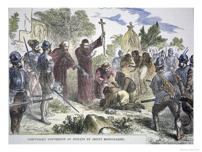
Primeros Libros (or First Books)
Primeros Libros provides digital images of the first books written in the Americas by Europeans going back to the 16th century. Students will be able to analyze and interpret texts written from the point of view of Europeans about the evangelism of Native Americans; as well as a close look at how Europeans perceived Native Americans and their culture.These monographs are very important because they represent the first printing in the New World and provide primary sources focused on a variety of academic fields.
|
The University of Texas at Austin
Students will be able to examine a collection of thirty-three first maps created by Europeans. The thirty-three maps comprising this exhibit illustrate the richness and variety of cartographic materials held by the Benson Latin American Collection. These materials date from the 1600s to the mid-1800s and include representative maps of all of Latin America and the Caribbean in formats ranging from hand-drawn plant dyes on velum to paper and ink maps produced on printing presses. The exhibit illustrates how knowledge of the physical geography of the region grew concurrent with significant advances in cartographic technique and the diffusion of artistic concepts and styles between European and Latin American cultures.
|

|

|
Library of Congress: What Came to Be Called America
The Library of Congress provides some digital primary sources about what came to be called "America." In it, you will find useful digital material, such as images and excerpts about the first Americans' culture written and drawn by Europeans. For example, students can explore interesting facts and images of how Native Americans lived and their social organization. It also offers imagery of Middle Atlantic Cultures, such as the Mexican Calendar developed by the people of Mexico prior to 1492, manuscripts about the people who inhabited different parts of Mexico and Mesoamerica, and images of Incan Culture.
|
National Geographic: Inca Empire
National Geographic has always been one of my favorite go-to- sites. The link will take students to a photo gallery of Incan artifacts found by archaeologists. The collection consist of images of Inca's masterful building skills; pictures of five century old mummies; as well as traditions like funerary bundle containing bare bones, which gives us an insight of the way the Chachapoya people kept their dead a thousand years ago; and much more. Students will get a perspective of how fascinating this civilization was by examining these great primary sources.
|

|
Primary Source Analysis Tools
Library of Congress
I would use this primary source analysis tool from the Library of Congress to have my students analyze an excerpt that I will provide alone with the primary source analysis tool. For example, students could analyze an image of a manuscript from the above website, Primeros Libros. Students are asked to identify and note details. I would present the question: What do you notice that you did not expect? What do you notice that you can't explain? Then, students write their observation in the "Observe" column of the analysis tool. Next questions: Where do you think this came from? Why do you think somebody wrote this? What do you think was happening when this was written? This encourages students to generate and test hypotheses about sources. Therefore, they will write their answer in the "Reflect" column. Lastly, students will answer what they think about who, what when, where, why, and how about the document, which they will write in the "Question" column. This part will encourage students to ask questions that will lead to more observations and reflections. In the "Further Investigation" section, students will be asked to identify questions appropriate for further investigation.
National Archives
Using one of the maps from the site above, The University of Texas at Austin, students will use the analysis tool to learn that by examining a map we can discern bias, just like with some written primary sources.
First, students will pay attention to the map's elements. They will look at the size of the map, elements that look strange or unfamiliar. Students will be able to name place or places that are not on the map. They will be encouraged to think why that is. What do you thinking the artist was trying to convey? Who was he trying to persuade, and why? By observing the map, students will learn to identify and note details. Students will be able to generate and test hypotheses about the source. For example, one of the main questions that students will be asked as they analyze the map is to think about why was the map made. Who do they think the audience was for the map? Students will be able to compare the map with more current ones. Furthermore, they will be able to infer about what the person who made the map knew and did not know.
First, students will pay attention to the map's elements. They will look at the size of the map, elements that look strange or unfamiliar. Students will be able to name place or places that are not on the map. They will be encouraged to think why that is. What do you thinking the artist was trying to convey? Who was he trying to persuade, and why? By observing the map, students will learn to identify and note details. Students will be able to generate and test hypotheses about the source. For example, one of the main questions that students will be asked as they analyze the map is to think about why was the map made. Who do they think the audience was for the map? Students will be able to compare the map with more current ones. Furthermore, they will be able to infer about what the person who made the map knew and did not know.
Lessons Using Primary Sources
DOCS TEACH: Titanic Survivors: One Ship, Two Different Worlds - this lesson is not related to my unit, but I am thinking about using this strategy to compare and contrast the Magna Carta and Bill of Rights, which are covered in World History.
Even though this lesson is not related to my unit, I would definitely use the strategies used here for analyzing primary sources.
